Hot Springs Road: Sentinel Rock - Katikati
Today is my sister's birthday. I've just got back from a morning tramp from the end of Hot Springs Road, in Katikati (known as Springs Road to the locals), to Sentinel Rock and back. It was only 7.73km but took me slightly under 3 hours to do. Part of the problem was the total ascent of 545m. Another part of the lengthy time I will get to later...
I had asked my brother-in-law what tracks might be interesting to do that were close by (I was staying at their place for the festivities). He suggested Sentinel Rock as one that could be done in a couple of hours or so, although he couldn't recall how long it had taken him when he'd been up there last. What he did say was that people were not allowed up on the rock itself, due to risk of landslides and death (keep this in mind for what comes).
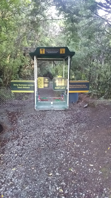
At the start of the track is a Kauri dieback washing station, similar to the one on Lindeman's Road, so that causes some delay going in and out (I'd estimate 10 minutes for both the entry and the exit washes, as I am thorough with them).
The first kilometre or so is a wide gravel path, until you reach the first junction, where you turn left.
Go pass the Kauri tree. There is another junction a little further on, so turn left at this second junction to leave the gravel path.
 |
| Likely the southern most Kauri tree |
From here it is mostly uphill and the track is narrow, windy, a bit muddy, and covered with roots. One thought I had while walking was that I hadn't encountered any scrambling on NZ trails, and I had encountered some while in the U.K. I was soon going to be corrected.
After an hour and ten minutes I reached the Sentinel Rock viewing point. The rock was covered with vegetation, so it blends in with the Kaimai mountain range beyond.
 |
| The camouflaged Sentinel Rock (look carefully, it's bigger than you think) |
The map showed the track continued on from the viewing point, so I continued. Eventually the trail split (to rejoin further along, the map showed), so I took the left path, which dropped down and ran alongside the ridge line. It rejoined the main trail and began ascending again, steeper and steeper.
Eventually I was trying to navigate up bare rock (smooth from eons of weather), which I managed, at least initially, due to the odd tree root to hang on to and the clumps of dirt from which ferns and native flax grew right at the edge of the rock. I could feel the sheer drop just the other side of that foliage, but I was keeping low and was not tempted to stand up to confirm my fears.
Eventually I came to a smooth rock-face I could not climb. I was about to give up when I saw off to my left a knotted rope hanging down. Obviously this was placed to aid people in climbing up. I, stupidly, thought that if the rope was there, this must be a well used and safe trail. I pulled on the rope and managed to climb up the rock face, eventually to the tree that said rope was attached to. Beyond that the climb was slightly less difficult but I had only gone up a few metres more when the ground dropped away off to my right and I could see across a wide expanse to the mountains beyond. My stomach dropped, as did I - right to the ground. I almost froze at that point, but convinced myself I would be stuck clinging to the side of this rock for days if I didn't move. The sheer drop was too daunting to navigate past for me, so I painstakingly made my way back down the cliff face.
Finally I made it back to more level ground, retreating back down the path. Back where the trail split, I took the left hand path (i.e. not the path I'd come up). It climbed the ridge line (as opposed to going around the hill) and partway up I found a sign that warned people not to go beyond that point (i.e where I was now coming from) as it was too dangerous!! Where was the warning sign on the other path???
Standing there beside the warning sign, I could see across to Sentinel Rock, which was very close, and I realised that I had actually been climbing the rock itself almost to the top (but didn't know it because of all of the foliage). Talk about risking my life.
I carried on along this track to eventually get to the point where the trail had originally split, then climbed back up to the viewing point.
 |
| The red X marks the warning sign location, not visible on the upward journey |
The time spent going beyond the viewing point had added at least 40 minutes to the entire walk. In hindsight, I should have stopped when I'd first arrived at the viewing point and then returned from there, which would have made the whole walk less than 2 hours.


Comments
Post a Comment