Karangahake Gorge (part of the Hauraki Rail Trail)
As the name implies, the Hauraki Rail Trail mostly follows what were once railway lines. The main trail runs 149km from Kaiaua, on the west side of the Hauraki Gulf, to Matamata, in the central Waikato. In addition, there is a 24km leg that branches off at Paeroa and runs to Waihi.
During the last week of July 2020 I had to take my car for a service and, as I haven't
had a car serviced in over 25 years (as I never had the need to own one),
I chose to take it to the place my sister goes in Waihi (where it had been serviced when owned by my nephew). Originally, I wanted to get to Paeroa, to walk the stretch of the
Hauraki Rail Trail from there to Waihi, but I had no way to
get there. So now the plan was to walk from the
Waihi end for half of the time I had available, then turn around and walk back.
I had done a little research online to try and determine where in Waihi the trail started and the best I could figure was that it was at the end of Lawrence Road (I later discovered I was wrong). I left mid-town Waihi about 9:10 a.m. and walked the 2+km along residential streets to the end of Lawrence Road (via Kenny Street and Galbraith Street), where I found the trail running off from the road down beside the Goldfields railway line.

A short distance along the trail (and just before a property with 2 continuous barking dogs) I came across this interesting memorial bench (which I sat on on the return journey, for reasons best left unsaid for now) overlooking a small creek.


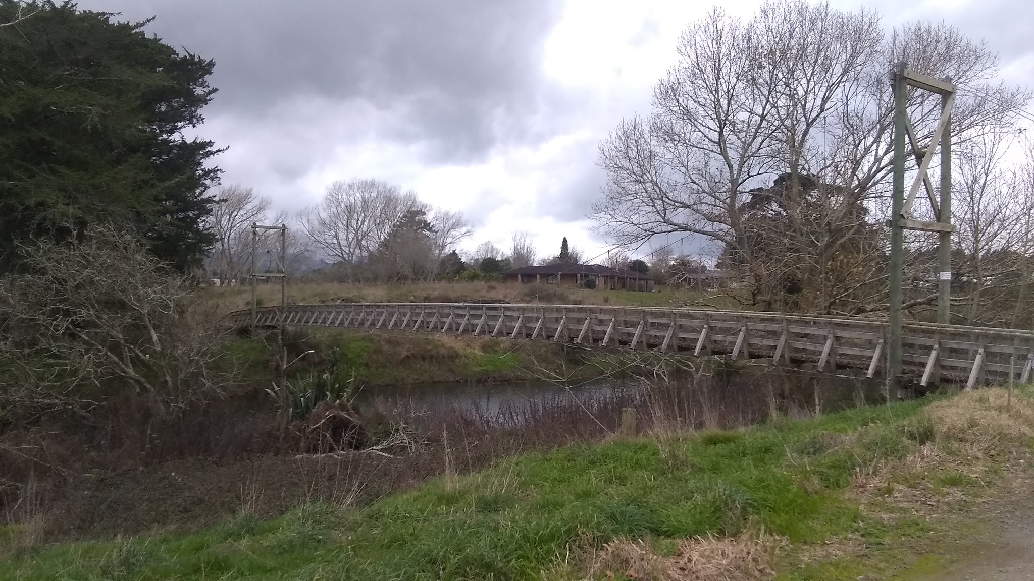
The trail soon crossed the Ohinemuri River via a bridge that had a bit of a bounce as you traversed over.


Across the other side, the trail hugs the south bank of the river all the way to Karangahake. This bit of the trail was interesting in the sense that the scenery was varied and pretty with pastoral land on the left and the river on the right. The trail itself was a wide stretch of gravel, unusually, interspersed with a couple of concrete sections.


Because of the abrupt meanderings of the river, at some point the river
(and trail) curved northward and the traffic on the highway was audible
for a stretch, which was annoying, but something I would either have to
learn to block out or tolerate as most of this trail ran within sight
and sound of the traffic.


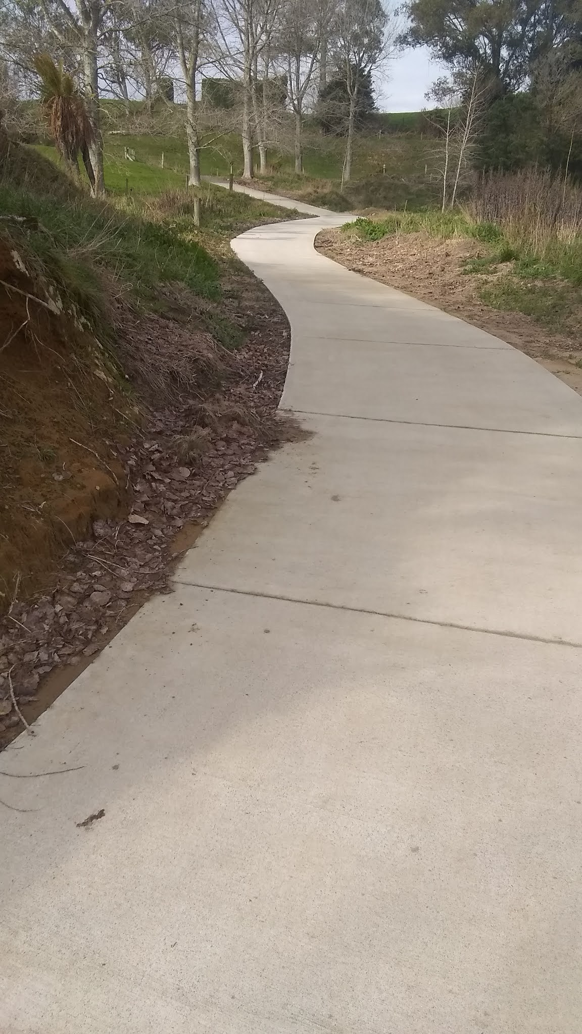
At first it was not obvious that the trail was an old railway line until I reached the first of many sections cut through the rock.

There was a small wetland conservation area that the trail passed through.


I encountered some early cyclists, mostly heading in the opposite direction, but one couple passed me from behind; the man with a backpack on containing a white poodle that was leaning to one side so it could see the path ahead over his shoulder.


Eventually the road ran just alongside the other side of the river and the sounds, and sight, of vehicles became common.


For a while there was little variety in the scenery until arriving opposite Waikino and at the first of the old mining remnants. The couple with the poodle had stopped to investigate the ruins, and I passed them and carried on.


A little further on was a bridge that gave access to the Waikino pub, just across the way, although it may not be currently operating as it seemed all closed up and there were no cars outside.


The stretch between the Falls road and the Karangahake tunnel was a bit monotonous.


Just before arriving at the bridge over the road leading into the tunnel the couple with the poodle passed me again, then stopped on the bridge ahead. As I approached I saw that there was an alternate route to the left, along the Windows walkway, so I chose that instead. It ran alongside the rapids and gave some stunning views.


Unfortunately some idiot had driven their car over the edge and left it as an eyesore down near the water.


A little further along were more mining remnants along with an option to walk up to an underground pump house on a circular walk.


I checked the time and it was almost 12, meaning I was at the point where I needed to turn around and head back in order to make it to the auto service place by 3, so I knew the pump house detour would have to wait for another day.
(5 days later insert) Luckily, I had to bring my car back to the auto service place the following week (just into August) and I walked this trail again (a portion of it in the opposite direction), but I included the underground pump house walk, so the following photos of that short loop are from that second day when I walked the Karangahake loop in a clockwise direction. Admittedly I did not notice when/where I encountered the underground pump house though, although I believe it was a locked off entrance just prior to me crossing the river over the suspension bridge.
I left the west side of the suspension bridge to head up the gorge.


I reached a bridge crossing the river. On the right there was a "locked" gate blocking the entrance to a cave/mine shaft. In hindsight, I believe this was the entrance to the underground pump house (but I'm not sure, and if you know and want to comment, please do so).

On the other side of the bridge you could continue along the trail all of the way up to Dickey Flat.

I did not have the time or stamina to do that, so I climbed the stairs to the tunnel system to see the "windows."


 |
| Overlooking part of the path I had walked a short while ago |

 |
| Again, overlooking where I had already walked |

Beyond the tunnels was more evidence of mining and a viewpoint that looked out over Karangahake.


(End of the 5 days later insert) Back to my original walking of the trail, I crossed the very bouncy suspension bridge, then saw a few more mining remnants. Directly across the river was the small settlement of Karangahake. One could cross a bridge to the car park opposite, but I was circling around to the tunnel.


Just along the path the poodle couple approached toward me from the opposite direction (as they had gone through the tunnel and around the north side of the gorge, while I had walked along the south side) and passed by.
There were some more mining structures on this side of Karangahake.


Coming across another bridge that spanned both the river and roads I approached the tunnel from the west end. There were a couple with a child just inside, but I soon caught up to them and passed them, walking briskly through. The tunnel itself was lit from orange lights along the centre of the roof line. Water dripped in several places.

Apparently the tunnel is 1km in length; at one point the exit seemed to just hang in the distance, not getting any nearer, but eventually I came to the end.


The afternoon return trip to Waihi took longer than the morning, with me averaging less than the 6km/hour that I managed earlier. I was only a few kilometres into the return journey when fatigue hit me; the muscles in my legs ached, one ankle had some pain, and my boots felt tight.
The views were the same, just reversed.


The three plus hours it took me to get back seemed to go on forever, with me constantly checking my hiking app to monitor distance and time. At one point I was hurting enough to want to sit down, which I did for a few minutes on a small dirt bank. I slowed my pace to a stroll and the pain eased.
Admittedly, this was the first walk in over 9 months that I had done that exceeded 16km, but today was almost dead flat where my other walks contained constant climbs and falls. After some deduction I put it down to wearing a pair of boots I had not worn too much in the past, that were a bit tight once my feet heated and swelled up, had no cushioning, and that I had not worn for a couple of years.
I knew I was getting closer to Waihi when the poodle couple passed me from behind again, this time telling me that I was doing an amazing job, as I had almost walked the same distance they had cycled in the same time, but I was thinking I was barely making headway by this point.
I rested again briefly on the bench I had taken a photo of earlier.
Finally, arriving back on the outskirts of Waihi, I saw the engine of the train that is used to take tourists out to the Waikino station and back.

Entering Waihi, I followed the short section of the trail I had not known about earlier to where I should have started the trail, the Waihi train station.

From there it was about one and a half kilometres back into town to arrive exactly 6 hours after I had left with a total of 34km walked, but I was somewhat stiff for the next two days. I was also told that the auto service place did not have all of the necessary parts to service my car, and that I would have to return next week to have the rest completed, along with getting the leaking radiator for a new one at a replacement cost of $350 plus installing. For someone on no income that came as a bit of a shock.
I returned the following week, walked the trail again, as well as the "windows walk" where the underground pump house was (the photos were included further up in the walk description), to total 35km, killed my right knee on the return journey (15km of pain), then got back to the auto service place to find out they had done no work on the car as the radiator had not arrived. So, I had to return a third day for the radiator (and spark plugs) to be installed, so I walked the Martha's Mine Pit Rim Walk that day, which I will post a blog about soon.


Comments
Post a Comment